Project Gallery
Featured Projects
Geographic Impacts of Global Change: Mapping the Stories of Californians by the Stanford Geospatial Center and BIO 128 Class.
Global warming and the effects of climate change pose great risks for Californians. Climate change will result in more frequent and more intense forest fires, more air pollution and deadly heat waves, a significant reduction in the snowpack and state water supplies, sea level rise and erosion along California's long coastline, and billions of dollars in damage to our agricultural, tourism, recreation, and other industries. These impacts have the potential to be hugely disruptive to how local governments operate.
This map was created by the BIO 128 class in collaboration with Felicia Bill of the Stanford Geospatial Center to present how forces of global change are manifested locally throughout California, with the intent to inform the public, businesses and policymakers about the human dimensions of environmental change.
Music, Race + Community in the SF Bay Area by the Stanford Geospatial Center.
Global warming and the effects of climate change pose great risks for Californians. Climate change will result in more frequent and more intense forest fires, more air pollution and deadly heat waves, a significant reduction in the snowpack and state water supplies, sea level rise and erosion along California's long coastline, and billions of dollars in damage to our agricultural, tourism, recreation, and other industries. These impacts have the potential to be hugely disruptive to how local governments operate.
This map was created by the BIO 128 class in collaboration with Felicia Bill of the Stanford Geospatial Center to present how forces of global change are manifested locally throughout California, with the intent to inform the public, businesses and policymakers about the human dimensions of environmental change.
Stanford Campus Mapping Project by the Stanford Geospatial Center.
The Stanford Geospatial Center, as part of its mission of supporting and enhancing geospatial instruction and research, has created a series of campus web mapping applications that showcase the latest trends in geospatial technology.
These interactive maps will serve as a platform for departments and libraries to make their services and resources available in an intuitive and functional way.
San Francisco Anti-Eviction Story Map by Jordan Carroll, Caroline Scanlon and Natasha Weiss.
This multimedia map aims to bring to life the experience of evicted individuals in San Francisco. Featured are the stories of five former or current residents of San Francisco who were evicted from their homes. The Anti-Eviction Mapping Project uses interactive maps to raise awareness and inspire collective action around the issue of no-fault evictions in the Bay Area.
Carleton Watkins Exhibit, Cartographic Visualizations by David Medeiros & the Stanford Geospatial Center.
A cartographic digital accompaniment to the Carleton Watkins exhibit at the Cantor Arts Center. The Stanford Geospatial Center created a series of cartographic visualizations to be used in digital apps and wall mounted displays that bring an additional dimension of geography and location to Watkins amazing images of Yosemite Valley, The Columbia River, and The Pacific Coast. In partnership with Stanford’s Center for Spatial and Textual Analysis, the Bill Lane Center for the American West, the Cantor Arts Center, and Branner Earth Sciences Library.
Mass Shootings in America: A Geographic Approach by the Stanford Geospatial Center
This website has been built by the Stanford Geospatial Center for the purpose of understanding the history of mass shootings in the United States over the past few decades. It is hoped that by presenting the data in visual form, patterns may emerge that can be studied to help prevent future tragedies and that this information contributes to the national debate.

The Effects of UV Exposure on Preterm Birth Rates in the United States by Dr. Paul Wise, Amy Showen, and Jeff Sweet.
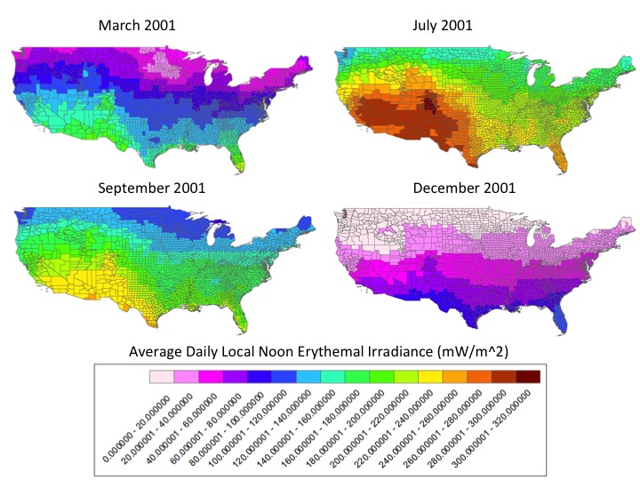
Preterm birth, or birth at less than 37 completed weeks of gestation, is a significant and persistent health problem in the United States and worldwide. In the United States, nearly half a million babies (or more than one out of every ten babies) are born premature each year, and survivors are at increased risk for acute complications and long-term sequelae. The causes of preterm birth are poorly understood, though it is associated with numerous complex and interrelated biological, psychological, and social risk factors. More recently, environmental exposures, such as pollutants and weather patterns, have been considered in attempting to explain the etiology of preterm birth. Sunlight, or more specifically UVB radiation, is an unexplored exposure that may plausibly be implicated in preterm birth due to its critical function in vitamin D synthesis. We used ArcGIS to explore whether different degrees of sun exposure in populations may influence preterm birth outcomes. This project is ongoing and nearing completion.
Factors Influencing the Movement of Syrian Refugees into Lebanon by Justin Brown, Benjamin Diego, Marissa Ferrante and Laura Zehender.
In spring of 2011, a popular uprising in Syria against the government of Bashar al-Assad, as part of the wider Middle Eastern protest movement known as the Arab Spring, grew into a full-fledged civil war. According to the United Nations High Commissioner for Refugees (UNCHR), more than 125,000 people have been killed in the Syrian conflict thus far. As a result, about one in four Syrians have left their homes, with over two million refugees fleeing into neighboring countries and more than five million internally displaced within Syria. As of November 30, 2013, over 800,000 registered Syrian refugees were residing in Lebanon (Syria Regional Refugee, 2013). This crisis in Syria has demanded global attention; in order to better understand the experience of the Syrian refugees and to identify their needed resources, the UNHCR and other agencies have created many spatio-analytical representations of Syrian populations in other countries. This project aims to analyze the spatial correlation between Syrian migration data with the cause and effect data for those migrations. It hopes to lead to a better understanding of the situations of Syrian refugees affected by the crisis.
Application of an Index Model to Predict Dissolved Nitrate Levels in Groundwater by Cheng Chen, Stephanie Chua, Angela Hayes, and Caitlin Scheder-Bieschin
Fertilizer is widely used to increase crop yield by farmers in the United States, and one of the main elements used in fertilizer is nitrogen. Although nitrogen helps crop productivity, too much nitrogen can be harmful to humans. As fertilizer use increases, the possibility that it contaminates groundwater also increases and human exposure is more likely to occur. Through research and the use of ArcGIS we wanted to answer the following two questions. Where in the San Joaquin Valley is there a high vulnerability of nitrate contamination of groundwater? How does this relate to measured values of dissolved nitrate in groundwater? The answers to these questions can help educate farmers on their fertilizer use and illustrate where people should be concerned about nitrate-contaminated drinking water.


 Stanford University Home