
Current Topics
New San Francisco Bay Trail Maps Now Available
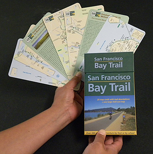
Photo: Brenda Kahn
May 6, 2013
The completely re-designed and updated San Francisco Bay Trail maps invite you to enjoy the 330 miles of completed shoreline paths. Easy-to-pack and easy-to-use, the San Francisco Bay Trail maps are now available for purchase at www.baytrail.org for $14.95, just in time for Bike to Work Day on May 9th. A companion online and mobile phone application are also available by visiting the website.
Conveniently packaged in a colorful box, 25 four-by-seven-inch map cards and a large fold-out map are essential tools to discovering the San Francisco Bay Trail — a shoreline walking and bicycling path that will one day encircle the entire Bay, stretching 500 miles through all nine Bay Area counties. With over 330 miles of trail currently in place, there’s a ride or a stroll for everyone from the long-time local to the first-time tourist. The maps were funded in part by the State Coastal Conservancy.
The Bay Trail passes through highly urbanized areas such as downtown San Francisco and natural areas such as the San Francisco Bay National Wildlife Refuge. It offers access to commercial, industrial, and residential neighborhoods; points of historic, natural and cultural interest; recreational areas such as beaches, marinas, fishing piers, boat launches, and over 130 parks and wildlife preserves. The Bay Trail offers access on paved multi-use paths, dirt trails, bike lanes, and sidewalks.
The San Francisco Bay Trail Project is a non-profit organization administered by the Association of Bay Area Governments (ABAG) and supported by the Metropolitan Transportation Commission (MTC).
![]()
info@mtc.ca.gov • Report Web site comments • Accessibility Information • Site Help
Metropolitan Transportation Commission • 101 Eighth Street, Oakland, California 94607
Phone:
(510) 817-5700, Fax: (510) 817-5848
For FasTrak® questions, contact the Customer Service Center: (877) 229-8655
This page was last modified Friday June 12, 2015
© 2015 MTC