Introduction :: BURMA
-
Various ethnic Burmese and ethnic minority city-states or kingdoms occupied the present borders through the 19th century. Over a period of 62 years (1824-1886), Britain conquered Burma and incorporated the country into its Indian Empire. Burma was administered as a province of India until 1937 when it became a separate, self-governing colony; in 1948, Burma attained independence from the British Commonwealth. Gen. NE WIN dominated the government from 1962 to 1988, first as military ruler, then as self-appointed president, and later as political kingpin. In response to widespread civil unrest, NE WIN resigned in 1988, but within months the military crushed student-led protests and took power.
Multiparty legislative elections in 1990 resulted in the main opposition party - the National League for Democracy (NLD) - winning a landslide victory. Instead of handing over power, the junta placed NLD leader (and Nobel Peace Prize recipient) AUNG SAN SUU KYI under house arrest from 1989 to 1995, 2000 to 2002, and from May 2003 to November 2010. In late September 2007, the ruling junta brutally suppressed protests over increased fuel prices led by prodemocracy activists and Buddhist monks, killing at least 13 people and arresting thousands for participating in the demonstrations. In early May 2008, Burma was struck by Cyclone Nargis, which left over 138,000 dead and tens of thousands injured and homeless. Despite this tragedy, the junta proceeded with its May constitutional referendum, the first vote in Burma since 1990. Legislative elections held in November 2010, which the NLD boycotted and were considered flawed by many in the international community, saw the ruling Union Solidarity and Development Party garner over 75% of the seats.
The national legislature convened in January 2011 and selected former Prime Minister THEIN SEIN as president. Although the vast majority of national-level appointees named by THEIN SEIN are former or current military officers, the government initiated a series of political and economic reforms leading to a substantial opening of the long-isolated country. These reforms included releasing hundreds of political prisoners, signing a nationwide cease-fire with several of the country's ethnic armed groups, pursuing legal reform, and gradually reducing restrictions on freedom of the press, association, and civil society. At least due in part to these reforms, AUNG SAN SUU KYI was elected to the national legislature in April 2012 and became chair of the Committee for Rule of Law and Tranquility. Burma served as chair of the Association of Southeast Asian Nations (ASEAN) for 2014. In a flawed but largely credible national legislative election in November 2015 featuring more than 90 political parties, the NLD again won a landslide victory. Using its overwhelming majority in both houses of parliament, the NLD elected HTIN KYAW, AUNG SAN SUU KYI’s confidant and long-time NLD supporter, as president. Burma's first civilian government after more than five decades of military dictatorship was sworn into office on 30 March 2016.
Geography :: BURMA
-
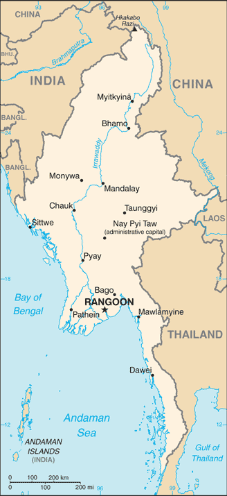
Southeastern Asia, bordering the Andaman Sea and the Bay of Bengal, between Bangladesh and Thailand
22 00 N, 98 00 E
Southeast Asia
total: 676,578 sq km
land: 653,508 sq km
water: 23,070 sq km
country comparison to the world: 40
slightly smaller than Texas
Area comparison map:

total: 6,522 km
border countries (5): Bangladesh 271 km, China 2,129 km, India 1,468 km, Laos 238 km, Thailand 2,416 km
1,930 km
territorial sea: 12 nm
contiguous zone: 24 nm
exclusive economic zone: 200 nm
continental shelf: 200 nm or to the edge of the continental margin
tropical monsoon; cloudy, rainy, hot, humid summers (southwest monsoon, June to September); less cloudy, scant rainfall, mild temperatures, lower humidity during winter (northeast monsoon, December to April)
central lowlands ringed by steep, rugged highlands
mean elevation: 702 m
elevation extremes: lowest point: Andaman Sea/Bay of Bengal 0 m
highest point: Gamlang Razi 5,870 m
petroleum, timber, tin, antimony, zinc, copper, tungsten, lead, coal, marble, limestone, precious stones, natural gas, hydropower, arable land
agricultural land: 19.2%
arable land 16.5%; permanent crops 2.2%; permanent pasture 0.5%
forest: 48.2%
other: 32.6% (2011 est.)
22,950 sq km (2012)
1,168 cu km (2011)
total: 33.23 cu km/yr (10%/1%/89%)
per capita: 728.6 cu m/yr (2005)
destructive earthquakes and cyclones; flooding and landslides common during rainy season (June to September); periodic droughts
deforestation; industrial pollution of air, soil, and water; inadequate sanitation and water treatment contribute to disease
party to: Biodiversity, Climate Change, Climate Change-Kyoto Protocol, Desertification, Endangered Species, Law of the Sea, Ozone Layer Protection, Ship Pollution, Tropical Timber 83, Tropical Timber 94
signed, but not ratified: none of the selected agreements
strategic location near major Indian Ocean shipping lanes
People and Society :: BURMA
-
noun: Burmese (singular and plural)
adjective: Burmese
Burman 68%, Shan 9%, Karen 7%, Rakhine 4%, Chinese 3%, Indian 2%, Mon 2%, other 5%
Burmese (official)
note: minority ethnic groups have their own languages
Buddhist 89%, Christian 4% (Baptist 3%, Roman Catholic 1%), Muslim 4%, Animist 1%, other 2%
56,320,206
note: estimates for this country take into account the effects of excess mortality due to AIDS; this can result in lower life expectancy, higher infant mortality, higher death rates, lower population growth rates, and changes in the distribution of population by age and sex than would otherwise be expected (July 2015 est.)
country comparison to the world: 25
0-14 years: 26.07% (male 7,485,419/female 7,194,500)
15-24 years: 18.02% (male 5,138,185/female 5,009,470)
25-54 years: 43.31% (male 12,132,302/female 12,261,750)
55-64 years: 7.24% (male 1,919,725/female 2,157,789)
65 years and over: 5.36% (male 1,313,711/female 1,707,355) (2015 est.)
population pyramid:

total dependency ratio: 49.1%
youth dependency ratio: 41.1%
elderly dependency ratio: 8%
potential support ratio: 12.5% (2015 est.)
total: 28.3 years
male: 27.7 years
female: 28.9 years (2015 est.)
country comparison to the world: 126
1.01% (2015 est.)
country comparison to the world: 116
18.39 births/1,000 population (2015 est.)
country comparison to the world: 97
7.96 deaths/1,000 population (2015 est.)
country comparison to the world: 101
-0.28 migrant(s)/1,000 population (2015 est.)
country comparison to the world: 124
urban population: 34.1% of total population (2015)
rate of urbanization: 2.49% annual rate of change (2010-15 est.)
RANGOON (Yangon) (capital) 4.802 million; Mandalay 1.167 million; Nay Pyi Taw 1.03 million (2015)
at birth: 1.06 male(s)/female
0-14 years: 1.04 male(s)/female
15-24 years: 1.03 male(s)/female
25-54 years: 0.99 male(s)/female
55-64 years: 0.89 male(s)/female
65 years and over: 0.77 male(s)/female
total population: 0.99 male(s)/female (2015 est.)
21.8 (2007 est.)
178 deaths/100,000 live births (2015 est.)
country comparison to the world: 54
total: 43.55 deaths/1,000 live births
male: 49.84 deaths/1,000 live births
female: 36.88 deaths/1,000 live births (2015 est.)
country comparison to the world: 48
total population: 66.29 years
male: 63.89 years
female: 68.82 years (2015 est.)
country comparison to the world: 171
2.16 children born/woman (2015 est.)
country comparison to the world: 102
46% (2009/10)
1.8% of GDP (2013)
country comparison to the world: 191
0.61 physicians/1,000 population (2012)
0.6 beds/1,000 population (2006)
improved:
urban: 92.7% of population
rural: 74.4% of population
total: 80.6% of population
unimproved:
urban: 7.3% of population
rural: 25.6% of population
total: 19.4% of population (2015 est.)
improved:
urban: 84.3% of population
rural: 73.9% of population
total: 77.4% of population
unimproved:
urban: 15.7% of population
rural: 26.1% of population
total: 22.6% of population (2012 est.)
0.69% (2014 est.)
country comparison to the world: 55
212,600 (2014 est.)
country comparison to the world: 27
10,100 (2014 est.)
country comparison to the world: 23
degree of risk: very high
food or waterborne diseases: bacterial and protozoal diarrhea, hepatitis A, and typhoid fever
vectorborne diseases: dengue fever, malaria, and Japanese encephalitis
water contact disease: leptospirosis
animal contact disease: rabies
note: highly pathogenic H5N1 avian influenza has been identified in this country; it poses a negligible risk with extremely rare cases possible among US citizens who have close contact with birds (2013)
2.9% (2014)
country comparison to the world: 172
22.6% (2010)
country comparison to the world: 27
0.8% of GDP (2011)
country comparison to the world: 172
definition: age 15 and over can read and write
total population: 93.1%
male: 95.2%
female: 91.2% (2015 est.)
total: 9 years
male: NA
female: NA (2007)
Government :: BURMA
-
conventional long form: Union of Burma
conventional short form: Burma
local long form: Pyidaungzu Thammada Myanma Naingngandaw (translated as the Republic of the Union of Myanmar)
local short form: Myanma Naingngandaw
former: Socialist Republic of the Union of Burma, Union of Myanmar
note: since 1989 the military authorities in Burma and the current parliamentary government have promoted the name Myanmar as a conventional name for their state; the US Government has not adopted the name
etymology: both "Burma" and "Myanmar" derive from the name of the majority Burmese Bamar ethnic group
parliamentary government took power in March 2011
name: Rangoon (Yangon); note - Nay Pyi Taw is the administrative capital
geographic coordinates: 16 48 N, 96 09 E
time difference: UTC+6.5 (11.5 hours ahead of Washington, DC, during Standard Time)
7 regions (taing-myar, singular - taing), 7 states (pyi ne-myar, singular - pyi ne), 1 union territory
regions: Ayeyawady (Irrawaddy), Bago, Magway, Mandalay, Sagaing, Taninthayi, Yangon (Rangoon)
states: Chin, Kachin, Kayah, Kayin, Mon, Rakhine (Arakan), Shan
union territory: Nay Pyi Taw
4 January 1948 (from the UK)
Independence Day, 4 January (1948); Union Day, 12 February (1947)
previous 1947, 1974 (suspended until 2008); latest approved by referendum 29 May 2008 (2015)
mixed legal system of English common law (as introduced in codifications designed for colonial India) and customary law
has not submitted an ICJ jurisdiction declaration; non-party state to the ICCt
citizenship by birth: no
citizenship by descent only: both parents must be citizens of Burma
dual citizenship recognized: no
residency requirement for naturalization: none
note: an applicant for naturalization must be the child or spouse of a citizen
18 years of age; universal
chief of state: President HTIN KYAW (since 30 March 2016); Vice Presidents MYINT SWE (since 30 March 2016) and HENRY VAN TIO (since 30 March 2016); note - the president is both chief of state and head of government
head of government: President HTIN KYAW (since 30 March 2016)
cabinet: Cabinet appointments shared by the president and the commander-in-chief
elections/appointments: president indirectly elected by simple majority vote by the full Assembly of the Nation from among 3 vice-presidential candidates nominated by the Presidential Electoral College (consists of members of the lower and upper houses and military members); the other two candidates become vice-presidents (president elected for a 5-year term); election last held on 15 March 2016 (next to be held in 2021)
election results: HTIN KYAW elected president; Assembly of the Union vote: HTIN KYAW 360, MYINT SWE 213, HENRY VAN TIO 79 (652 votes cast)
description: bicameral Assembly of the Union or Pyidaungsu consists of an upper house - the House of Nationalities or Amyotha Hluttaw, (224 seats; 168 members directly elected in single-seat constituencies by absolute majority vote with a second round if needed and 56 appointed by the military; members serve 5-year terms) and a lower house - the House of Representatives or Pyithu Hluttaw, (440 seats; 330 members directly elected in single-seat constituencies by simple majority vote and 110 appointed by the military; members serve 5-year terms)
elections: last held on 8 November 2015 (next to be held in 2020)
election results: Upper House - percent of vote by party - NA; seats by party - NLD 135, USDP 11, ANP 10, SNLD 3, ZCD 2, TNP 2, independent 2, other 3, military appointees 56; Lower House - percent of vote by party - NA; seats by party - NLD 255, USDP 30, ANP 12, SNLD 12, PNO 3, TNP 3, ZCD 2, LNDP 2, independent 1, other 3, canceled due to insurgence 7, military appointees 110
highest court(s): Supreme Court of the Union (consists of the chief justice and 7-11 judges)
judge selection and term of office: chief justice and judges nominated by the president, with approval of the Lower House, and appointed by the president; judges normally serve until mandatory retirement at age 70
subordinate courts: High Courts of the Region; High Courts of the State; Court of the Self-Administered Division; Court of the Self-Administered Zone; district and township courts; special courts (for juvenile, municipal, and traffic offenses); courts martial
All Mon Region Democracy Party or AMRDP [NAING NGWE THEIN]
Arakan National Party or ANP [Dr. AYE MAUNG] (formed from the 2013 merger of the Rakhine Nationalities Development Party and the Arakan League for Democracy)
National Democratic Force or NDF [KHIN MAUNG SWE]
National League for Democracy or NLD [AUNG SAN SUU KYI]
National Unity Party or NUP [THAN TIN]
Pa-O National Organization or PNO [AUNG KHAN HTI]
Shan Nationalities Democratic Party or SNDP [SAI AIK PAUNG]
Shan Nationalities League for Democracy or SNLD [KHUN HTUN OO]
Ta'ang National Party or TNP [AIK MONE]
Union Solidarity and Development Party or USDP [HTAY OO]
Zomi Congress for Democracy or ZCD [PU CIN SIAN THANG]
numerous smaller parties
Thai border: Ethnic Nationalities Council or ENC
Federation of Trade Unions-Burma or FTUB (exile trade union and labor advocates)
National Coalition Government of the Union of Burma or NCGUB (self-proclaimed government in exile) ["Prime Minister" Dr. SEIN WIN] consists of individuals, some legitimately elected to the People's Assembly in 1990 (the group fled to a border area and joined insurgents in December 1990 to form a parallel government in exile)
National Council-Union of Burma or NCUB (exile coalition of opposition groups)
United Nationalities Federal Council or UNFC
inside Burma: Kachin Independence Organization
Karen National Union or KNU
Karenni National People's Party or KNPP
United Wa State Army or UWSA
88 Generation Students (pro-democracy movement)
several other Chin, Karen, Mon, and Shan factions
note: many restrictions on freedom of expression have been relaxed by the government; a limited number of political groups, other than parties, are approved by the government
ADB, ARF, ASEAN, BIMSTEC, CP, EAS, EITI (candidate country), FAO, G-77, IAEA, IBRD, ICAO, ICRM, IDA, IFAD, IFC, IFRCS, IHO, ILO, IMF, IMO, Interpol, IOC, IOM, IPU, ISO (correspondent), ITU, ITUC (NGOs), NAM, OPCW (signatory), SAARC (observer), UN, UNCTAD, UNESCO, UNIDO, UNWTO, UPU, WCO, WHO, WIPO, WMO, WTO
chief of mission: Ambassador KYAW MYO HTUT (since 3 December 2013)
chancery: 2300 S Street NW, Washington, DC 20008
telephone: [1] (202) 332-3344
FAX: [1] (202) 332-4351
consulate(s) general: Los Angeles, New York
chief of mission: Ambassador (vacant)
embassy: 110 University Avenue, Kamayut Township, Rangoon
mailing address: Box B, APO AP 96546
telephone: [95] (1) 536-509, 535-756, 538-038
FAX: [95] (1) 511-069
design consists of three equal horizontal stripes of yellow (top), green, and red; centered on the green band is a large white five-pointed star that partially overlaps onto the adjacent colored stripes; the design revives the triband colors used by Burma from 1943-45, during the Japanese occupation
chinthe (mythical lion); national colors: yellow, green, red, white
name: "Kaba Ma Kyei" (Till the End of the World, Myanmar)
lyrics/music: SAYA TIN
note: adopted 1948; Burma is among a handful of non-European nations that have anthems rooted in indigenous traditions; the beginning portion of the anthem is a traditional Burmese anthem before transitioning into a Western-style orchestrated work
Economy :: BURMA
-
Since the transition to a civilian government in 2011, Burma has begun an economic overhaul aimed at attracting foreign investment and reintegrating into the global economy. Economic reforms have included establishing a managed float of the Burmese kyat in 2012, re-writing the Foreign Investment Law in 2012 to allow more foreign investment participation, granting the Central Bank operational independence in July 2013, enacting a new Anti-corruption Law in September 2013, and granting licenses to nine foreign banks in 2014 and four more foreign banks in 2016.
The government’s commitment to reform, and the subsequent easing of most Western sanctions, led to accelerated growth in 2013 and 2014. In 2015 growth slowed because of political uncertainty in an election year, summer floods, and external factors, including China’s slowdown and lower commodity prices. Burma’s abundant natural resources, young labor force, and proximity to Asia’s dynamic economies have attracted foreign investment in the energy sector, garment industry, information technology, and food and beverages. Pledged foreign direct investment grew from $4.1 billion in FY 2013 to $8.1 billion in FY 2014.
Despite these improvements, living standards have not improved for the majority of the people residing in rural areas. Burma remains one of the poorest countries in Asia – approximately 26% of the country’s 51 million people live in poverty. The previous government’s isolationist policies and economic mismanagement have left Burma with poor infrastructure, endemic corruption, underdeveloped human resources, and inadequate access to capital, which will require a major commitment to reverse. The Burmese government has been slow to address impediments to economic development such as insecure land rights, a restrictive trade licensing system, an opaque revenue collection system, and an antiquated banking system. The newly elected government, led by AUNG SAN SUU KYI, will likely focus on accelerating agricultural productivity and land reforms, modernizing and opening the financial sector, and improving fiscal management.
$267.7 billion (2015 est.)
$246.8 billion (2014 est.)
$227.5 billion (2013 est.)
note: data are in 2015 US dollars
country comparison to the world: 58
$65.78 billion (2015 est.)
8.5% (2015 est.)
8.5% (2014 est.)
8.4% (2013 est.)
country comparison to the world: 7
$5,200 (2015 est.)
$4,800 (2014 est.)
$4,400 (2013 est.)
note: data are in 2015 US dollars
country comparison to the world: 165
16.3% of GDP (2015 est.)
19.4% of GDP (2014 est.)
17.7% of GDP (2013 est.)
country comparison to the world: 106
household consumption: 76.8%
government consumption: 3.9%
investment in fixed capital: 21%
investment in inventories: 0.3%
exports of goods and services: 31.7%
imports of goods and services: -33.7%
(2015 est.)
agriculture: 36.1%
industry: 22.3%
services: 41.6% (2015 est.)
rice, pulses, beans, sesame, groundnuts; sugarcane; fish and fish products; hardwood
agricultural processing; wood and wood products; copper, tin, tungsten, iron; cement, construction materials; pharmaceuticals; fertilizer; oil and natural gas; garments; jade and gems
12.2% (2015 est.)
country comparison to the world: 3
36.18 million (2015 est.)
country comparison to the world: 18
agriculture: 70%
industry: 7%
services: 23% (2001 est.)
5% (2015 est.)
5.1% (2014 est.)
country comparison to the world: 52
32.7% (2007 est.)
lowest 10%: 2.8%
highest 10%: 32.4% (1998)
revenues: $2.682 billion
expenditures: $4.471 billion (2015 est.)
4.1% of GDP (2015 est.)
country comparison to the world: 215
-2.7% of GDP (2015 est.)
country comparison to the world: 97
1 April - 31 March
9.2% (2015 est.)
5.5% (2014 est.)
country comparison to the world: 205
9.95% (31 December 2010)
12% (31 December 2009)
country comparison to the world: 22
13% (31 December 2015 est.)
13% (31 December 2014 est.)
country comparison to the world: 56
$13.47 billion (31 December 2015 est.)
$14.07 billion (31 December 2014 est.)
country comparison to the world: 71
$15.41 billion (31 December 2015 est.)
$16.91 billion (31 December 2014 est.)
country comparison to the world: 91
$NA
-$5.867 billion (2015 est.)
-$3.851 billion (2014 est.)
country comparison to the world: 171
$9.752 billion (2015 est.)
$8.962 billion (2014 est.)
note: official export figures are grossly underestimated due to the value of timber, gems, narcotics, rice, and other products smuggled to Thailand, China, and Bangladesh
country comparison to the world: 90
natural gas; wood products; pulses and beans; fish; rice; clothing; minerals, including jade and gems
China 63%, Thailand 15.8%, India 5.7% (2014)
$12.64 billion (2015 est.)
$12.17 billion (2014 est.)
note: import figures are grossly underestimated due to the value of consumer goods, diesel fuel, and other products smuggled in from Thailand, China, Malaysia, and India
country comparison to the world: 89
fabric; petroleum products; fertilizer; plastics; machinery; transport equipment; cement, construction materials; food products� edible oil
China 42.4%, Thailand 19%, Singapore 10.9%, Japan 5.4% (2014)
$9.417 billion (31 December 2015 est.)
$8.727 billion (31 December 2014 est.)
country comparison to the world: 77
$6.616 billion (31 December 2014 est.)
$7.367 billion (31 December 2013 est.)
country comparison to the world: 121
kyats (MMK) per US dollar -
1,171.8 (2015 est.)
984.35 (2014 est.)
984.35 (2013 est.)
853.48 (2012 est.)
815 (2011 est.)
Energy :: BURMA
-
10.48 billion kWh (2012 est.)
country comparison to the world: 95
7.765 billion kWh (2012 est.)
country comparison to the world: 101
0 kWh (2013 est.)
country comparison to the world: 110
0 kWh (2013 est.)
country comparison to the world: 124
3.591 million kW (2012 est.)
country comparison to the world: 86
24.8% of total installed capacity (2012 est.)
country comparison to the world: 188
0% of total installed capacity (2012 est.)
country comparison to the world: 55
75.2% of total installed capacity (2012 est.)
country comparison to the world: 20
0% of total installed capacity (2012 est.)
country comparison to the world: 159
20,000 bbl/day (2014 est.)
country comparison to the world: 72
2,717 bbl/day (2012 est.)
country comparison to the world: 77
40 bbl/day (2012 est.)
country comparison to the world: 84
50 million bbl (1 January 2015 est.)
country comparison to the world: 79
15,780 bbl/day (2012 est.)
country comparison to the world: 99
25,000 bbl/day (2013 est.)
country comparison to the world: 120
0 bbl/day (2012 est.)
country comparison to the world: 158
8,557 bbl/day (2012 est.)
country comparison to the world: 142
13.1 billion cu m (2013 est.)
country comparison to the world: 37
4.6 billion cu m (2013 est.)
country comparison to the world: 61
8.5 billion cu m (2013 est.)
country comparison to the world: 24
0 cu m (2013 est.)
country comparison to the world: 166
283.2 billion cu m (1 January 2014 est.)
country comparison to the world: 38
13.34 million Mt (2012 est.)
country comparison to the world: 93
Communications :: BURMA
-
total subscriptions: 530,000
subscriptions per 100 inhabitants: 1 (2014 est.)
country comparison to the world: 96
total: 26.6 million
subscriptions per 100 inhabitants: 48 (2014 est.)
country comparison to the world: 47
general assessment: meets minimum requirements for local and intercity service for business and government
domestic: system barely capable of providing basic service; mobile-cellular phone system is grossly underdeveloped
international: country code - 95; landing point for the SEA-ME-WE-3 optical telecommunications submarine cable that provides links to Asia, the Middle East, and Europe; satellite earth stations - 2, Intelsat (Indian Ocean) and ShinSat (2011)
government controls all domestic broadcast media; 2 state-controlled TV stations with 1 of the stations controlled by the armed forces; 2 pay-TV stations are joint state-private ventures; access to satellite TV is limited; 1 state-controlled domestic radio station and 9 FM stations that are joint state-private ventures; transmissions of several international broadcasters are available in parts of Burma; the Voice of America (VOA), Radio Free Asia (RFA), BBC Burmese service, the Democratic Voice of Burma (DVB), and Radio Australia use shortwave to broadcast in Burma; VOA, RFA, and DVB produce daily TV news programs that are transmitted by satellite to audiences in Burma
AM 1, FM 2, shortwave 3 (2007)
4 (2008)
.mm
1,055 (2012)
country comparison to the world: 172
total: 646,700
percent of population: 1.2% (2014 est.)
country comparison to the world: 128
Transportation :: BURMA
-
64 (2013)
country comparison to the world: 76
total: 36
over 3,047 m: 12
2,438 to 3,047 m: 11
1,524 to 2,437 m: 12
under 914 m: 1 (2013)
total: 28
over 3,047 m: 1
1,524 to 2,437 m: 4
914 to 1,523 m: 10
under 914 m: 13 (2013)
11 (2013)
gas 3,739 km; oil 551 km (2013)
total: 5,031 km
narrow gauge: 5,031 km 1.000-m gauge (2008)
country comparison to the world: 38
total: 34,377 km (includes 358 km of expressways) (2010)
country comparison to the world: 93
12,800 km (2011)
country comparison to the world: 10
total: 29
by type: cargo 22, passenger 2, passenger/cargo 3, specialized tanker 1, vehicle carrier 1
foreign-owned: 2 (Germany 1, Japan 1)
registered in other countries: 3 (Panama 3) (2010)
country comparison to the world: 86
major seaport(s): Moulmein, Sittwe
river port(s): Rangoon (Yangon) (Rangoon River)
Military and Security :: BURMA
-
Myanmar Armed Forces (Tatmadaw): Army (Tatmadaw Kyi), Navy (Tatmadaw Yay), Air Force (Tatmadaw Lay) (2013)
18-35 years of age (men) and 18-27 years of age (women) for voluntary military service; no conscription (a 2010 law reintroducing conscription has not yet entered into force); 2-year service obligation; male (ages 18-45) and female (ages 18-35) professionals (including doctors, engineers, mechanics) serve up to 3 years; service terms may be stretched to 5 years in an officially declared emergency; Burma signed the Convention on the Rights of the Child (CRC) on 15 August 1991; on 27 June 2012, the regime signed a Joint Action Plan on prevention of child recruitment; in February 2013, the military formed a new task force to address forced child conscription; approximately 600 children have been released from military service since the signing of the joint action plan (2015)
Transnational Issues :: BURMA
-
over half of Burma's population consists of diverse ethnic groups who have substantial numbers of kin in neighboring countries; the Naf River on the border with Bangladesh serves as a smuggling and illegal transit route; Bangladesh struggles to accommodate 29,000 Rohingya, Burmese Muslim minority from Arakan State, living as refugees in Cox's Bazar; Burmese border authorities are constructing a 200 km (124 mi) wire fence designed to deter illegal cross-border transit and tensions from the military build-up along border with Bangladesh in 2010; Bangladesh referred its maritime boundary claims with Burma and India to the International Tribunal on the Law of the Sea; Burmese forces attempting to dig in to the largely autonomous Shan State to rout local militias tied to the drug trade, prompts local residents to periodically flee into neighboring Yunnan Province in China; fencing along the India-Burma international border at Manipur's Moreh town is in progress to check illegal drug trafficking and movement of militants; over 90,000 mostly Karen refugees and asylum seekers fleeing civil strife, political upheaval, and economic stagnation in Burma were living in remote camps in Thailand near the border as of year-end 2013
IDPs: up to 662,400 (government offensives against armed ethnic minority groups near its borders with China and Thailand) (2015)
stateless persons: 1.45 million (2014); note - Rohingya Muslims, living in Rakhine State, are Burma's main group of stateless people; the Burmese Government does not recognize the Rohingya as a "national race" and stripped them of their citizenship under the 1982 Citizenship law, categorizing them as "non-national" or "foreign residents"; under the Rakhine State Action Plan drafted in October 2014, the Rohingya must demonstrate their family has lived in Burma for at least 60 years to qualify for a lesser naturalized citizenship and the classification of Bengali or be put in detention camps and face deportation; native-born but non-indigenous people, such as Indians, are also stateless; the Burmese Government does not grant citizenship to children born outside of the country to Burmese parents who left the country illegally or fled persecution, such as those born in Thailand
current situation: Burma is a source country for men, women, and children trafficked for the purpose of forced labor and for women and children subjected to sex trafficking; Burmese adult and child labor migrants travel to East Asia, the Middle East, South Asia, and the US, where men are forced to work in the fishing, manufacturing, forestry, and construction industries and women and girls are forced into prostitution, domestic servitude, or forced labor in the garment sector; some Burmese economic migrants and Rohingya asylum seekers have become forced laborers on Thai fishing boats; some military personnel and armed ethnic groups unlawfully conscript child soldiers or coerce adults and children into forced labor; domestically, adults and children from ethnic areas are vulnerable to forced labor on plantations and in mines, while children may also be subject to forced prostitution, domestic service, and begging
tier rating: Tier 2 Watch List – Burma does not fully comply with the minimum standards for the elimination of trafficking, but it is making significant efforts to do so; the government has a written plan that, if implemented, would constitute making a significant effort toward meeting the minimum standard for eliminating human trafficking; in 2014, law enforcement continued to investigate and prosecute cross-border trafficking offenses but did little to address domestic trafficking; no civilians or government officials were prosecuted or convicted for the recruitment of child soldiers, a serious problem that is hampered by corruption and the influence of the military; victim referral and protection services remained inadequate, especially for men, and left victims vulnerable to being re-trafficked; the government coordinated anti-trafficking programs as part of its five-year national action plan (2015)
world's third largest producer of illicit opium with an estimated production in 2012 of 690 metric tons, an increase of 13% over 2011, and poppy cultivation in 2012 totaled 51,000 hectares, a 17% increase over 2011; production in the United Wa State Army's areas of greatest control remains low; Shan state is the source of 94.5% of Burma's poppy cultivation; lack of government will to take on major narcotrafficking groups and lack of serious commitment against money laundering continues to hinder the overall antidrug effort; major source of methamphetamine and heroin for regional consumption (2013)