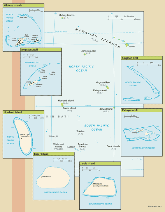
All of the following US Pacific island territories except Midway Atoll constitute the Pacific Remote Islands National Wildlife Refuge (NWR) Complex and as such are managed by the Fish and Wildlife Service of the US Department of the Interior. Midway Atoll NWR has been included in a Refuge Complex with the Hawaiian Islands NWR and also designated as part of Papahanaumokuakea Marine National Monument. These remote refuges are the most widespread collection of marine- and terrestrial-life protected areas on the planet under a single country's jurisdiction. They sustain many endemic species including corals, fish, shellfish, marine mammals, seabirds, water birds, land birds, insects, and vegetation not found elsewhere.
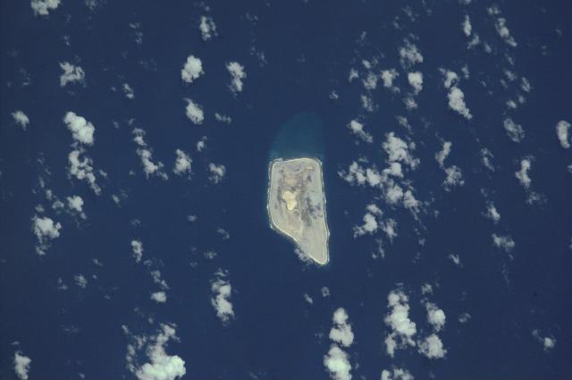
Baker Island: The US took possession of the island in 1857. Its guano deposits were mined by US and British companies during the second half of the 19th century. In 1935, a short-lived attempt at colonization began on this island but was disrupted by World War II and thereafter abandoned. The island was established as a NWR in 1974.
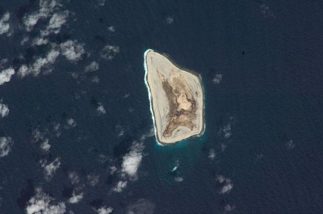
Howland Island: Discovered by the US early in the 19th century, the uninhabited atoll was officially claimed by the US in 1857. Both US and British companies mined for guano deposits until about 1890. In 1935, a short-lived attempt at colonization began on this island, similar to the effort on nearby Baker Island, but was disrupted by World War II and thereafter abandoned. The famed American aviatrix Amelia EARHART disappeared while seeking out Howland Island as a refueling stop during her 1937 round-the-world flight; Earhart Light, a day beacon near the middle of the west coast, was named in her memory. The island was established as a NWR in 1974.
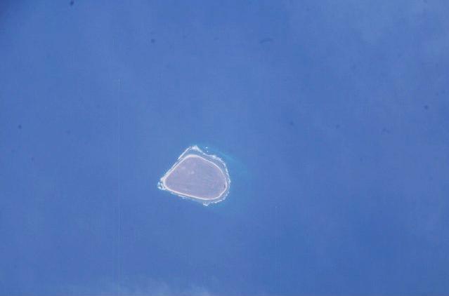
Jarvis Island: First discovered by the British in 1821, the uninhabited island was annexed by the US in 1858 but abandoned in 1879 after tons of guano had been removed. The UK annexed the island in 1889 but never carried out plans for further exploitation. The US occupied and reclaimed the island in 1935. It was abandoned in 1942 during World War II. The island was established as a NWR in 1974.
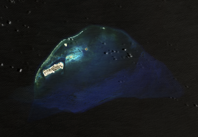
Johnston Atoll: Both the US and the Kingdom of Hawaii annexed Johnston Atoll in 1858, but it was the US that mined the guano deposits until the late 1880s. Johnston and Sand Islands were designated wildlife refuges in 1926. The US Navy took over the atoll in 1934. Subsequently, the US Air Force assumed control in 1948. The site was used for high-altitude nuclear tests in the 1950s and 1960s. Until late in 2000 the atoll was maintained as a storage and disposal site for chemical weapons. Munitions destruction, cleanup, and closure of the facility were completed by May 2005. The Fish and Wildlife Service and the US Air Force are currently discussing future management options; in the interim, Johnston Atoll and the three-mile Naval Defensive Sea around it remain under the jurisdiction and administrative control of the US Air Force.
Kingman Reef: The US annexed the reef in 1922. Its sheltered lagoon served as a way station for flying boats on Hawaii-to-American Samoa flights during the late 1930s. There are no terrestrial plants on the reef, which is frequently awash, but it does support abundant and diverse marine fauna and flora. In 2001, the waters surrounding the reef out to 12 nm were designated a NWR.
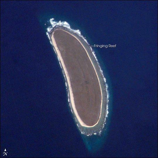
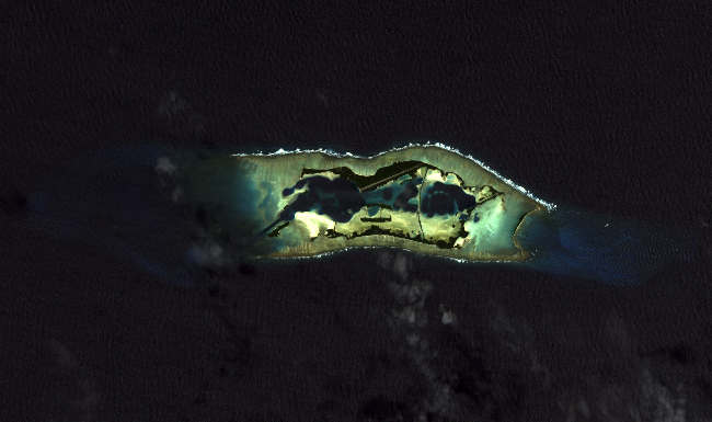
Midway Islands: The US took formal possession of the islands in 1867. The laying of the transpacific cable, which passed through the islands, brought the first residents in 1903. Between 1935 and 1947, Midway was used as a refueling stop for transpacific flights. The US naval victory over a Japanese fleet off Midway in 1942 was one of the turning points of World War II. The islands continued to serve as a naval station until closed in 1993. Today the islands are a NWR and are the site of the world's largest Laysan albatross colony.
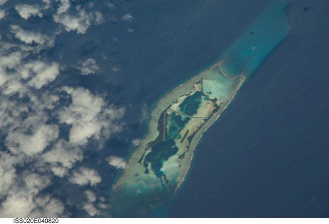
Palmyra Atoll: The Kingdom of Hawaii claimed the atoll in 1862, and the US included it among the Hawaiian Islands when it annexed the archipelago in 1898. The Hawaii Statehood Act of 1959 did not include Palmyra Atoll, which is now partly privately owned by the Nature Conservancy with the rest owned by the Federal government and managed by the US Fish and Wildlife Service. These organizations are managing the atoll as a wildlife refuge. The lagoons and surrounding waters within the 12-nm US territorial seas were transferred to the US Fish and Wildlife Service and designated a NWR in January 2001.
Oceania
Baker Island: atoll in the North Pacific Ocean 1,830 nm southwest of Honolulu, about halfway between Hawaii and Australia
Howland Island: island in the North Pacific Ocean 1,815 nm southwest of Honolulu, about halfway between Hawaii and Australia
Jarvis Island: island in the South Pacific Ocean 1,305 nm south of Honolulu, about halfway between Hawaii and Cook Islands
Johnston Atoll: atoll in the North Pacific Ocean 717 nm southwest of Honolulu, about one-third of the way from Hawaii to the Marshall Islands
Kingman Reef: reef in the North Pacific Ocean 930 nm south of Honolulu, about halfway between Hawaii and American Samoa
Midway Islands: atoll in the North Pacific Ocean 1,260 nm northwest of Honolulu near the end of the Hawaiian Archipelago, about one-third of the way from Honolulu to Tokyo
Palmyra Atoll: atoll in the North Pacific Ocean 960 nm south of Honolulu, about halfway between Hawaii and American Samoa
Baker Island: 0 13 N, 176 28 W
Howland Island: 0 48 N, 176 38 W
Jarvis Island: 0 23 S, 160 01 W
Johnston Atoll: 16 45 N, 169 31 W
Kingman Reef: 6 23 N, 162 25 W
Midway Islands: 28 12 N, 177 22 W
Palmyra Atoll: 5 53 N, 162 05 W
Oceania
total - 6,959.41 sq km; emergent land - 22.41 sq km; submerged - 6,937 sq km
Baker Island: total - 129.1 sq km; emergent land - 2.1 sq km; submerged - 127 sq km
Howland Island: total - 138.6 sq km; emergent land - 2.6 sq km; submerged - 136 sq km
Jarvis Island: total - 152 sq km; emergent land - 5 sq km; submerged - 147 sq km
Johnston Atoll: total - 276.6 sq km; emergent land - 2.6 sq km; submerged - 274 sq km
Kingman Reef: total - 1,958.01 sq km; emergent land - 0.01 sq km; submerged - 1,958 sq km
Midway Islands: total - 2,355.2 sq km; emergent land - 6.2 sq km; submerged - 2,349 sq km
Palmyra Atoll: total - 1,949.9 sq km; emergent land - 3.9 sq km; submerged - 1,946 sq km
country comparison to the world: 239
Baker Island: about 2.5 times the size of the National Mall in Washington, DC
Howland Island: about three times the size of the National Mall in Washington, DC
Jarvis Island: about eight times the size of the National Mall in Washington, DC
Johnston Atoll: about 4.5 times the size of the National Mall in Washington, DC
Kingman Reef: a little more than 1.5 times the size of the National Mall in Washington, DC
Midway Islands: about nine times the size of the National Mall in Washington, DC
Palmyra Atoll: about 20 times the size of the National Mall in Washington, DC
none
Baker Island: 4.8 km
Howland Island: 6.4 km
Jarvis Island: 8 km
Johnston Atoll: 34 km
Kingman Reef: 3 km
Midway Islands: 15 km
Palmyra Atoll: 14.5 km
territorial sea: 12 nm
exclusive economic zone: 200 nm
Baker, Howland, and Jarvis Islands: equatorial; scant rainfall, constant wind, burning sun
Johnston Atoll and Kingman Reef: tropical, but generally dry; consistent northeast trade winds with little seasonal temperature variation
Midway Islands: subtropical with cool, moist winters (December to February) and warm, dry summers (May to October); moderated by prevailing easterly winds; most of the 107 cm of annual rainfall occurs during the winter
Palmyra Atoll: equatorial, hot; located within the low pressure area of the Intertropical Convergence Zone (ITCZ) where the northeast and southeast trade winds meet, it is extremely wet with between 400-500 cm of rainfall each year
low and nearly flat sandy coral islands with narrow fringing reefs that have developed at the top of submerged volcanic mountains, which in most cases rise steeply from the ocean floor
elevation extremes: lowest point: Pacific Ocean 0 m
highest point: Baker Island, unnamed location - 8 m; Howland Island, unnamed location - 3 m; Jarvis Island, unnamed location - 7 m; Johnston Atoll, Sand Island - 10 m; Kingman Reef, unnamed location - less than 2 m; Midway Islands, unnamed location - 13 m; Palmyra Atoll, unnamed location - 3 m
terrestrial and aquatic wildlife
agricultural land: 0%
arable land 0%; permanent crops 0%; permanent pasture 0%
forest: 0%
other: 100% (2011 est.)
Baker, Howland, and Jarvis Islands: the narrow fringing reef surrounding the island poses a maritime hazard
Kingman Reef: wet or awash most of the time, maximum elevation of less than 2 m makes Kingman Reef a maritime hazard
Midway Islands, Johnston, and Palmyra Atolls: NA
Baker, Howland, and Jarvis Islands, and Johnston Atoll: no natural freshwater resources
Kingman Reef: none
Midway Islands and Palmyra Atoll: NA
Baker, Howland, and Jarvis Islands: scattered vegetation consisting of grasses, prostrate vines, and low growing shrubs; primarily a nesting, roosting, and foraging habitat for seabirds, shorebirds, and marine wildlife; closed to the public
Johnston Atoll: Johnston Island and Sand Island are natural islands, which have been expanded by coral dredging; North Island (Akau) and East Island (Hikina) are manmade islands formed from coral dredging; the egg-shaped reef is 34 km in circumference; closed to the public
Kingman Reef: barren coral atoll with deep interior lagoon; closed to the public
Midway Islands: a coral atoll managed as a National Wildlife Refuge and open to the public for wildlife-related recreation in the form of wildlife observation and photography
Palmyra Atoll: the high rainfall and resulting lush vegetation make the environment of this atoll unique among the US Pacific Island territories; supports a large undisturbed stand of Pisonia beach forest