Out West Blog

Notes, photos and updates from the Center's student researchers and summer interns working at organizations across the region.
Summer 2016 Internships Open for Applications
We are pleased to announce that our Summer 2016 internship offerings are now online. This year, we have added three new internship host organizations: the Trust for Public Lands, the Pacific Northwest Scenic Trail and the Santa Lucia Conservancy. In addition, we are debuting a brand new program called Stanford Energy Internships in California, aimed at exposing Stanford students to the complex world of energy policy in Sacramento. Stipends for our internships range from $4,000 to $6,000.
Internships offer students an immersive experience to learn hands-on about a variety of issues facing our diverse region. Undergraduates should apply by Tuesday, February 9 at 5 pm.
Read more about our summer internships program and browse the listings »
Student Researchers Trace California's Coastal Act and the Agency it Spawned

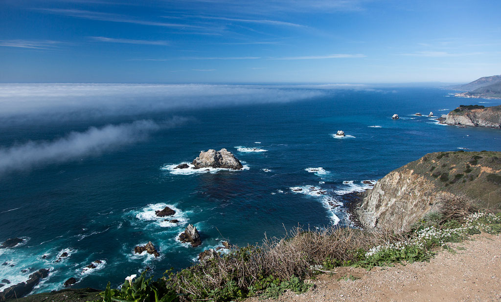
The Big Sur coastline (Photo: Vadim Kurland via Flickr)
Imagine the state of California without its coastline: a thousand miles of sand dunes, forests, rocky inlets, marinas, muscle beaches, and coastal mountains. While the state's constitution enshrines coastal access as a right of every Californian, citizens looked seaward with alarm in the early 1970s as an oil spill fouled the waters off Santa Barbara and some extravagant development projects sought to bar the public from beloved beaches.
The result was the Coastal Act of 1972, a ballot measure passed with 52.5% of the vote, with strong support among Central and Southern counties along the coast. The Act led to the establishment of the California Coastal Commission, a public agency charged with protecting the coast, regulating development, and ensuring continued public access to a coastal zone extending three miles out to sea.
Its mandate placed the Coastal Commission at odds with powerful political and economic forces in California, and over the four decades since its establishment, its budget has been chipped away, its full-time staff declining nearly by half since 1980. “For some people, the Coastal Commission is their least favorite agency,” says Quito Tsui, a research assistant for the Bill Lane Center for the American West.
Four decades since the Coastal Act, how has a small agency fared at regulating development along a vast shoreline? Two groups of research assistants spent the summer of 2015 working for the Center's California Coastal Commission project to trace the origins of the agency, and assess the cumulative work done under its aegis.
Examining the Commission's Localized Implementation
One of the keys to the Commission's effectiveness may be a decentralized structure and reliance on localized implementation. The Commission is divided into six regional offices, these offices in turn look to local communities to produce their own development plans – with public comment and input.
The research assistants Elana Leone and Quito Tsui – advised by the Center's Iris Hui – sought to examine the Local Coastal Programs (LCPs) created by local municipalities and under the supervision of the Coastal Commission.
Leone and Tsui approached their survey with three principal questions:
- How did the Local Coastal Programs they studied align with the Coastal Act?
- What degree of influence does the Coastal Act have on these LCPs?
- How much autonomy does the LCP program give to local jurisdictions and their residents?


Elana Leone, left, and Quito Tsui
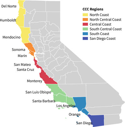
Tsui and Leone looked at seven Local Coastal Programs produced within two of the Coastal Commission's six zones: the North Central Coast zone running southward from Sonoma to San Francisco, and the Central Coast zone extending south from San Mateo to Monterey counties.
In their report, entitled “A Closer Look at Local Coastal Programs: A Case Study of the North Central Coast,” the authors explored the seven plans in depth, creating a matrix for point by point comparison, and mapped critical areas in each of the local communities, from wetlands to coastal structures, erosion hot spots, and areas threatened by sea level rise. Despite many commonalities, the program documents varied widely in length, scope, and issue focus.

Coastal Commission regions (enlarge)
“We found that despite the Coastal Act’s unquestionable influence on the LCPs in the North Central Coast,” write Leone and Tsui, “that each coastal jurisdiction has some flexibility in establishing its own priorities.” The authors noted, for example, that while Marin county was explicity devoted to protecting and supporting its coastal agriculture, the coastal plans for Daly City, Half Moon Bay and Pacifica were primarily concerned with urban issues like affordable housing and coastal access. This is understandable given the great difference in size and urban density between Marin and the latter urban areas.
But other differences were harder to reconcile: why, Leone and Tsui ask, did only some of the LCPs address bluff erosion and rising sea levels, when coastal hazards like these are felt equally among all of the communities they surveyed? In particular, they asked why San Francisco's LCP doesn't address flooding or flood prevention, given the number of residents in the coastal zone. “This lack of consistency across the board,” they write, “can have significant policy consequences given the seriousness of the threats dune erosion, bluff erosion and flooding pose to the North Central Coast.”
Despite the shortcomings of individual plans, Leone and Tsui conclude that the variation among the LCPs overall is a positive result of the Commission's decentralization of coastal management. "Despite the possibility of the Coastal Act whitewashing local areas and their unique characteristics," the authors write, "we instead found that the Coastal Act is in fact a malleable document that more often than not, works with local governments to create a document that protects the interests of both local areas and the coast."
When Seeking Water Savings, Increasing Agricultural Efficiency Could Backfire

Strawberries receiving drip irrigation on a Watsonville, CA farm during the summer of 2015. (USDA via Flickr)
This past spring, a New York Times editorial thundered against California farmers’ use of flood irrigation amid the state’s ongoing drought. The authors urged farmers to “switch from flood irrigation or inefficient sprinklers to drip or microspray systems, which use less water.”
According to the Center’s Vanessa Casado-Perez and Maggie Niu (’17), the Times’ editorials – and others like them – suffer from a flaw in conventional wisdom about agricultural water use during drought. Drip and microspray irrigation systems, while more efficient, often do not end up conserving water at all. Instead, says Niu, a research assistant for Casado-Perez during the summer of 2015, “efficient technologies like drip irrigation actually consume more water than older methods,” which generate return flows that can be reused by other farmers. Because drip and microspray systems deliver water directly to the crop in small quantities, the water is either entirely absorbed or lost to evaporation.


Maggie Niu, left, and Vanessa Casado-Pérez
As a result, Niu and Casado Perez write, “promotion of drip or sprinklers may backfire: they may divert less water and produce more in a single plot of land, but they may consume more water than flood, thus having negative systemic effects.”
Water Conservation Goals and Policies May Be Misaligned
Niu and Casado-Perez wondered if the mismatch between the stated goal – water conservation – and the technical solution – increasing efficiency – was one that affected the water policies of many western states, one that might limit their ability to achieve water conservation.
Research Surveys Western State Water Policies
For a forthcoming paper entitled “Agricultural Water Conservation Policies in the West,” the authors examined conservation regulations and legislative statutes in seventeen states from up in the Dakotas and Texas westward. Pointing out that the official definition of agricultural conservation is “reducing the amount of water used on farms,” they point out that “the reality is much more complex.”
In their paper they find that conservation programs vary widely. Many states mention conservation in their codes and water plans, but for several, like Idaho and Nevada, participation is strictly voluntary. By contrast, parts of Arizona have some of the most stringent conservation requirements. Conservation plans vary also in their scope – local, as in Texas, or statewide – and at whom the measures are aimed, whether individual farmers or entire irrigation districts.
Federal Program is Also Problematic
Niu and Casado-Perez also looked at the Environmental Quality Incentives Program (EQIP), funded by the federal government and managed in partnership with the states. EQIP subsidizes farmers looking to switch to more efficient irrigation systems – generally drip irrigation. They found that while EQIP identifies its goal as natural resource conservation, nowhere does the text define what that means, nor how switching to efficient watering systems would bring real water savings. “EQIP,” they conclude, “takes for granted that the adoption of efficient irrigation systems will achieve the desired goal.”

Surface waterways and flood irrigation flow valves bring irrigation water to drought-affected Livingston, California in July 2015. (USDA via Flickr)
Finding Models in State Legislative Statutes
Failing to find evidence of robust conservation either in state codes or in a widely used federal program, the authors turned to state legislative statutes “aimed at solely promoting the conservation of water.” They found measures like these in four states they studied: Montana, Washington, California and Oregon.
Of these statutes, Niu and Casado-Perez conclude that California’s legal framework is the one that most clearly prioritizes reduced water consumption. Like the others, it incentivizes farmers to save water by granting them full or partial right to the water they conserve, which they can then lease or sell this water to another right holder. Additionally, however, California’s law is the only one that requires a net reduction in consumption for water rights holders to retain their right.
In summation, the authors say that states “should tailor legislation to fit the water supply and demand of their state, focusing on whether increased efficiency will bring them more benefits, even with the possibility of increasing consumption, or whether conserving water is their priority.”
But states should never assume that pursuing one goal will achieve the other.
Ice Patches, Holes in the Ground, and Other Adventures in Yellowstone National Park

By Peter Salazar
B.A., History, 2015
Summer Intern at the Archeology Department, Yellowstone National Park
Read about our summer interns on the Out West student blog. Throughout the summer, the Center's interns and Research Assistants will be sending in virtual postcards, snapshots and reports on their summer work.
As much as I might have expected the pace of change and dynamism of my job in the Yellowstone Park Archaeologist’s office to slow in the final few weeks, no such thing actually occurred. I could hardly settle into a comfortable office routine before a new task or challenge would rise up and present itself for contemplation or resolution. My day-to-day task of updating, editing, and cleaning up the 2000 park site file records found regular and happy interruption in a number of other projects that continued to expose me further more to the world of archaeology and cultural resource management.
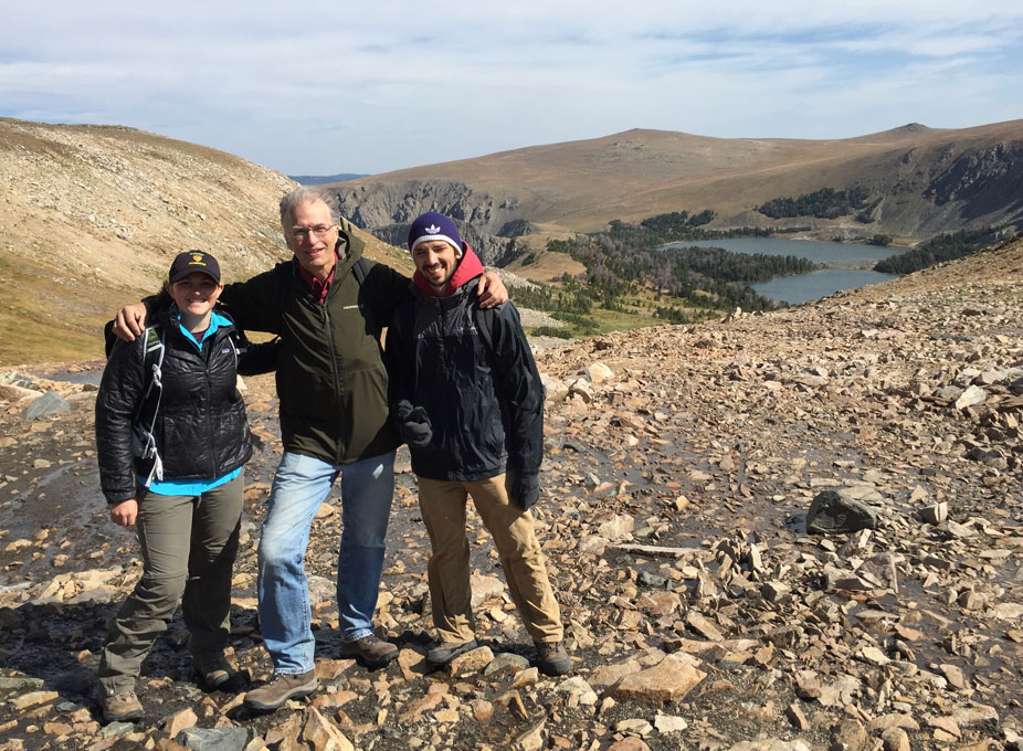
My experience working with GIS software, for example, allowed me to assist my supervisor in updating the park archaeological map, clearing out inconsistencies and filling in data that would make the rather unwieldy map to function in its capacity as a directory for the location and content of all of the park’s archaeological sites. I also had the opportunity to join my supervisor and a group of other natural and cultural resource management professionals on an educational excursion to the Beartooth Mountains (right next to the northeast entrance to the park) to explore the topic of ice patch archaeology, that is, scouring the rapidly melting ice patches of the high alpine regions of the vicinity for artifacts emerging after thousands of years. While we didn’t have any sensational finds on this particular excursion (aside from a well-preserved sheep skull and a spear shaft fragment), the exercise was a fascinating exposure to the issue of how cultural resource management is affected by such a far-reaching issue as global climate change.
And a description of my final few weeks in Yellowstone would be woefully lacking without a reference to my role participating in the Fishing Bridge construction monitoring. A scheduled update of a water main was taking place at Fishing Bridge, one of the principal intersections in the middle of the park, and an extremely sensitive archaeological site – it was there that the only pre-Columbian burials in the entire park were found. Another volunteer and I in the office, Melanie Langa, supervised the work and made sure that nothing of an archaeologically sensitive nature was being disturbed. It’s hard enough to methodically analyze stratigraphy, soil changes, and artifact density in a controlled excavation setting. But when your scientific instrument changes from a trowel to a backhoe, the task becomes exponentially more difficult. Unfortunately (or perhaps thankfully), we did not stumble across any buried settlements or treasure troves, but the exercise was nevertheless a fascinating lesson in geology and archaeological field methods.
I’m sad to go, of course. Yellowstone is a remarkable and breathtaking place to spend one’s summer. I became fond of saying to others that I would be more than happy to scrub toilets all summer, and I would still consider myself to have the emerged with a sweet deal for having been able to live in the park. To be able to live in the park and spend my time doing something that I loved and found interesting, however, makes an already dreamy situation that much better. I don’t know if I’ll end up pursuing a career in archaeology at this point, but this experience was nevertheless a fascinating introduction to the world of careful compromise, concession and dialogue that takes place in the stewardship of natural and cultural resources.
A ‘Peace’ of Something Greater

Image: Historical mapping of the Walnut Creek watershed is the culmination of months of archival research, data compilation and synthesis, and georeferencing of historical maps. The above image shows an incomplete version of the mapping, still with many features to be added and problems to resolve.
By Tyler McIntosh
B.S. Earth Systems, 2016
Summer Intern at the San Francisco Estuary Institute
Read about our summer interns on the Out West student blog. Throughout the summer, the Center's interns and Research Assistants will be sending in virtual postcards, snapshots and reports on their summer work.
As this summer has spun by, so too have many projects at the San Francisco Estuary Institute (SFEI). From data collection trips in southern California to the California Climate Change Symposium in Sacramento, I’ve traveled and learned, learned as I’ve traveled, and changed as I’ve learned.
My time with SFEI is coming to a close, and as I look back I wonder where it all went. Time does indeed fly when you’re… learning about historical ecology? I suppose that there is an answer to where the time went: the majority of my contributions were to the Walnut Creek: Flood Control 2.0 project, a small piece of the dynamic puzzle of flood prevention in the Bay Area.
From my first days at SFEI through to my last, I’ve helped shepherd the Walnut Creek project through the winding pathways of historical ecology research. Data finding, collection, and compilation were followed by synthesis and digitization with a GIS. As the summer comes to a close, the Walnut Creek project progresses into the stages of analysis and reporting, which, sadly, I won’t have the time to contribute to. The project is slated to continue into 2017. However, I did assist in report writing, copyediting, and reference compilation for the Tijuana River Historical Ecology project, which is at a later stage of its life. The combination of these two projects (in addition to smaller, more tangential tasks) gave me a chance to learn about environmental science, myself, and my future path.
The future is always tied to our past, within ourselves as well as when examining landscapes. I landed in the United States thirty-six hours before walking into SFEI for the first time. I had just returned from three months of studying and traveling in Chile and Argentina. Prior to picking up and leaving on my adventures, I had made the decision to switch my major from Mechanical Engineering to Earth Systems. Although the decision had been made, my mind was filled with uncertainty throughout my wanderings in South America. Had I made a mistake?
Perhaps the most important thing that I have gotten out of this summer is a sense of peace: I have come to terms with the decision I made, and now feel excited and able to move forward. With SFEI’s help, I’ve gained an understanding of the lumbering machine that is the environmental sector and where I may fit into it. While I may not become a historical ecologist, my work this summer has formed the perfect springboard from which to vault into the upcoming year of study and brought my pre-existing interest in the environment to new levels. Although I hope to move in the direction of applying my quantitative engineering to the challenges of environmental science, communication remains in the back of my mind. In today’s world it is unacceptable for scientists to exist within the polished boundaries of the ivory tower—even if one is not directly involved in communication, it is essential to consider how one’s work will be communicated, and what its role is in the now critical world of policy and public environmentalism. I am, as the Fleet Foxes sing, “a functioning cog in some great machinery, serving something beyond me.”


