Download and print a Parcel Report detailing pertinent information about a lot or parcel within the City of Palo Alto by using the new “Online Parcel Report” tool. Click on link below!
You can also have the Parcel Report emailed to you, usually within 2 business days of your request, by filling out the Parcel Report Request Form.
For more information, contact the Planner on Duty at the Development Services Center at (650) 329-2441 or planner@cityofpaloalto.org.
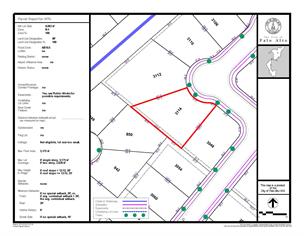
Parcel Report Details
APN or Assessor’s Parcel Number - number assigned to parcels of real property by the county tax assessor of a particular jurisdiction for purposes of identification and record-keeping.
Net Lot Size – size of the lot from lot line to lot line. Development Potential is based on the net lot area and while gross and net lot area are the same for most lots in Palo Alto, there are some lots for which portions must be excluded (e.g. street right of way, portions of flag lots, creek or waterway channel) from the gross lot area to establish the net lot area. In these cases, a “CANNOT ASSESS” will be the value. Please see page 3 “Gross vs. net lot area” in the Single Family Zoning Technical Manual or contact the Planner on Duty at Development Services for more information.
Net Lot Size for condominiums or “Air Parcels” - In cases where the property is in an ownership multifamily development where individuals own a unit, such as condominiums or properties with homeowners associations, the displayed value will be an estimate of the size of the unit. The value does NOT indicate the lot area of the entire development. Please contact the Planner on Duty at Development Services for more information.
Zone – Zoning District for the property. Please refer to Title 18 of the municipal code for more information. For additional information on R-1 or R-1 (xxxx) zoning districts, please refer to the Single Family Zoning Technical Manual.
Zone % - percentage of the parcel within the specified Zoning District.
Land Use Designation – Comprehensive Plan or General Plan designation for the property. Please refer to the Comprehensive Plan - Land Use Element for more information.
Land Use Designation % - percentage of the parcel within the specified Land Use Designation.
Flood Zone – Federal Emergency Management Agency (FEMA) flood zone for the property. Please refer to the Public Works Department Flood Plain Management page for more information.
LOMA – Letter of Map Amendment amending the FEMA flood zone for the property. Please refer to the Public Works Department Flood Plain Management page for more information.
Airport Influence Area – indicates if the property is within an Airport Influence Area. Please refer to Program L2-B and Page L-7 of the Comprehensive Plan - Land Use Element for more information.
Historic Status – indicates if the property is in the City’s Historic Inventory, within a Historic District, or has historic significance. Please refer to the Historic Resources Board page for more information.
Homer/Emerson Corridor Frontage - indicates if the property is in the Homer/Emerson Corridor Frontage. Please see South of Forest Area - SOFA II Plan for possible requirements.
Easements – indicates if there are recorded easements on or adjacent to the property. Please visit the Development Services for more information.
Underlying Lot Lines – indicates if there are any underlying lot lines within or adjacent to the property. Please visit the Development Services for more information.
Near Creek Feature – indicates if the property is within 75 feet of a creek or a waterway channel. There may be lot size or flood zone implications. Please see page 3 “Gross vs. net lot area” in the Single Family Zoning Technical Manual if the property is in Zoning District R-1/R-1 (xxxx) or contact the Planner on Duty at Development Services for more information.
Distance between sidewalk and pl (Property Line) – The area between the sidewalk edge and the property line is part of the public right of way. Setbacks are measured from the property line and NOT from edge of sidewalk. The distance between the sidewalk and the property line varies in different areas of Palo Alto. Please see page 22 “Setback Considerations” in the Single Family Zoning Technical Manual if the property is in Zoning District R-1/R-1 (xxxx) or contact the Planner on Duty at Development Services to determine distance between sidewalk edge and property line.
Most of the fields below “Distance between Sidewalk and pl” can only be assessed if the property is in an R-1/R-1 (xxxx) zoning district (Single Family Residential Zoning district). If the property is in a zoning district other than R-1/R-1 (xxxx), the values will indicate “CANNOT ASSESS FOR THIS ZONE”.
Substandard – indicates if the R-1/R-1 (xxxx) zoned property is considered substandard. Please see page 2 “Substandard Lots” on the Single Family Zoning Technical Manual for more information.
Flag Lot – indicates if the property is considered a flag lot (interior lot that is either a landlocked parcel which has a driveway easement across another lot abutting a street, or a lot having limited frontage providing only enough width for a driveway to reach the buildable area of the lot which is located behind another lot abutting a street). Please see the Single Family Zoning Technical Manual for more information on flag lots in the R-1/R-1 (xxxx) zoning district or contact the Planner on Duty at Development Services for more information on flag lots in general.
Cottage – indicates if the R-1/R-1 (xxxx) zoned property meets the minimum lot size to have a second dwelling unit or cottage that is subordinate to the main dwelling. Please see page 44 “2nd dwelling units standards & site planning” in the Single Family Zoning Technical Manual for more information.
Max Floor Area - allowable gross floor area on an R1/R1 (xxxx) zoned lot reflecting the cumulative square footage of all visible levels. Please see page 4 in the Single Family Zoning Technical Manual for more information.
Max Lot Coverage – allowable lot coverage on an R1/R1 (xxxx) zoned lot describing how much of the lot is covered by structures. Please see page 4 in the Single Family Zoning Technical Manual for more information.
Max Height to Ridge – allowable height on an R1/R1 (xxxx) zoned lot. Please see page 46 in the Single Family Zoning Technical Manual for more information.
Special Setbacks – certain streets have special setbacks which override standard setbacks unless a larger contextual setback applies. Please see page 20 in Single Family Zoning Technical Manual for more information.
Minimum Setbacks – the distance of a structure or other feature from the property line. Also referred to as required yards surrounding the buildable area of the lot. Required yards are meant to be open space areas and are important as landscaping opportunities. Please see page 20 in Single Family Zoning Technical Manual for more information.
For further information, contact the Planner on Duty at the Development Services Center at (650) 329-2441 or planner@cityofpaloalto.org.