
Dedicated to advancing scholarly and public understanding of the past, present, and future of western North America, the Center supports research, teaching, and reporting about western land and life in the United States, Canada, and Mexico.
Chau Ho Heads East – At Least for Now

We’re proud to announce that Minh Chau Ho, the Center’s program associate, is headed to the University of Michigan later this month to begin the fully funded Frontiers master’s program in ecology and evolutionary biology.
In her nearly two years at the Center, Chau has coordinated our undergraduate offerings: research assistantships, summer internships, the American West interdisciplinary survey course and (last but not least) our Sophomore College field course, where she wrangled 12 sophomores as they traversed Wyoming to study energy issues.
Most of all, though, we will remember Chau as the intrepid leader, clad in a purple knit cap, whom we followed for 20 miles from Stanford to the Sea. We will miss her substantial contributions, but we are always excited when a member of our community gets a great opportunity to pursue a field she loves. Please join us in wishing happy trails to Chau.
Understanding California’s Wilderness Landscape
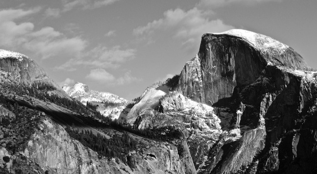
First protected in 1864, Yosemite was California’s First National Park. 100 years later, part of the park was designated as a wilderness under the Wilderness Act of 1964. (Photo: Kira Minehart)
Kira Minehart will graduate from Stanford in the spring of 2016 with a B.S. in earth systems and a notation in science communication from the Program in Writing in Rhetoric. She is interested in land use, ecology, and environmental communication. Her independent research through the Bill Lane Center for the American West attempts to measure the ecology of Californian wilderness areas using geospatial analysis.
The wilderness act of 1964 states that wilderness is “an area where the earth and its community of life are untrammelled by man, where man himself is a visitor who does not remain.” This legislation set aside 9.1 million acres of wilderness that has grown to over 104 million acres, with the majority located in the western U.S. These protected areas are devoid of roads, buildings, and motorized vehicles. Aside from these stipulations, the definition of wilderness is as fluid as a flowing river.

Figure 1. (click to enlarge)
1. Coast Range
4. Cascades
5. Sierra Nevada
6. Central California Foothills and Coastal Mountains
7. Central California Valley
8. Southern California Mountains
9. Eastern Cascades Slopes and Foothills
13. Central Basin and Range
14. Mojave Basin and Range
78. Klamath Mountains/California High North Coast Range
80. Northern Basin and Range
81. Sonoran Basin and Range
85. Southern California/Northern Baja Coast
For my research project, I attempted to define California’s wilderness areas through an academic approach integrating geospatial analysis and ecological data. My questions were: Which landscapes are most and least protected as federally designated wilderness areas? Which environmental factors do we deem congruent with the wilderness ideal?
I gathered data from two main sources for this project. The Wilderness Institute at the University of Montana’s College of Forestry and Conservation created the first dataset, which depicts the boundaries of federally protected wilderness areas in California. The second dataset contains “ecoregions,” which divide California into regions on the basis of biotic and abiotic features, including elevation, vegetation, geology, soils, climate, and more. James Omernik created this data in 1987 and has since collaborated with the EPA and other federal agencies to improve the results. For this analysis, I overlaid these two datasets, called shapefiles, in order to determine what ecoregions wilderness areas represented.
My preliminary results differed from my expectations based on the stereotypical perceptions of wilderness. I expected most of the protected wilderness to be in forest ecoregions, like the Sierra Nevada, Klamath Mountains, or Coast Range. Instead, I found that 42% of wilderness areas in California represented the Mojave Basin and Range ecoregion. This ecoregion is home to iconic National Parks like Joshua Tree and Death Valley. The Sierra Nevada ecoregion came in second place, including places like Yosemite and Sequoia-Kings Canyon National Park. The Northern Basin and Range, which harbors only one wilderness area (South Warner Wilderness), and the Coast Range ecoregions were the least protected by wilderness areas.

Table 1. Representation of ecoregions in California’s wilderness areas. Nearly 14% of California’s area is protected as wilderness.
In order to provide one possible explanation for my findings, I decided to compare population data with my preliminary results. I overlaid my wilderness data with a shapefile of 2014 census data depicting population by county. My results show that population density and wilderness areas are generally inversely located. As urban sprawl continues to push the limits of human civilization further and further, population density will likely play a key role in determining which areas can be set aside as wilderness.


Figures 2-4. (click to enlarge) Map of California’s wilderness landscape including population density data. Colored polygons represent wilderness areas, where each color corresponds to a particular ecoregion. Shades of grey indicate population density. Darkest shades are high-density population, where lighter to white shades are low-density population centers.
I would love to continue this project by combining my results with existing datasets of socioeconomic, political, or biological features to learn more. For example, land price data could provide meaningful results about wilderness placement, as it would demonstrate whether or not the wilderness areas were designated based on economic concerns. Since California is an agricultural hotspot, I would also like to examine wilderness in relation to agricultural suitability. In both cases, I hypothesize that lands with high land rents or opportunity costs for alternate land uses wouldn’t be designated as wilderness areas.
These landscapes provide aesthetic, educational, and recreational benefits that are unique to their untrammeled boundaries. Aside from land cover, wilderness areas represent an invaluable land use demonstrated by ecosystem services and American culture. Henry David Thoreau once said, “In wildness is the preservation of the world.” I think wilderness areas have benefits still unknown to us, particularly regarding the ecosystem services they offer. A wilderness can never be re-established once destroyed, which is why I support further research of these areas. Through increasing our understanding of wilderness areas, we may predict and control the trajectory of land protection (or destruction) in the future. I simply hope that we can protect these places so future generations may enjoy and benefit from them.
Dynamics of Change in the 20th-Century Pacific Northwest

Treaty fishermen spearing salmon on rapids of the Columbia River near Celilo Falls, Oregon. Photograph taken by Arthur M. Prentiss before March 1957, when The Dalles Dam inundated the historic fishing site. (Public domain via University of Oregon Digital Collection)
John J. Dougherty joined the Center as a Postdoctoral Scholar after receiving his PhD in Ethnic Studies from the University of California-Berkeley. He is working on a book manuscript entitled "Flooded by Progress," a history of hydropower's transformation of the Columbia River Basin. An abbreviated book chapter was recently featured in Western Legal History.
In 1941, the United State Department of the Interior hired Woody Guthrie, the renowned American folksinger, to author a series of songs about the hydroelectric development of the Columbia River. Guthrie’s collection, known as the Columbia River Songs, sought to garner regional support for a new and unprecedented era of industrial development in the Pacific Northwest.

In his most famous ballad about the Columbia River, Guthrie sings: “Roll on Columbia, roll on/Your power is turning our darkness to dawn/So roll on, Columbia, roll on.” Guthrie’s ballad proved prophetic, as hydropower began to dramatically transform the region like never before. But by the 1970s the story had changed. Over thirty years of extensive industrial development had exacted a significant price on the region’s once abundant natural resources, and new policies of environmental protection and preservation emerged. In 1976, Joe Frazier, a columnist for The Associated Press, commented that the region’s once abundant natural resources had been sacrificed to the “god of cheap hydroelectric power.” It was obvious that the same technologies that made harvest possible in the first place now began to threaten it.
As a postdoctoral scholar at the Bill Lane Center, I’m working on a book manuscript about this period of Pacific Northwest history, titled "Flooded by Progress." This project expands our understanding of this period in a too-often-overlooked way, by asking the question: what role did federal Indian tribes of the Pacific Northwest play in the demographic, economic and environmental transformation of the region in the second half of the 20th century?
This project examines the politics of federal Indian law and the changing environmental landscape in the Pacific Northwest from the 1940s to present. It argues that the changing legal status of Native lands and resources was instrumental in both the industrial expansion of the region and the environmental changes associated with the increased development of natural resources. This project directly utilizes Western environmental history to help narrate Native American and Pacific Northwest history. From the era of resource abundance of the late 1940s to the era of resource scarcity by the 1970s, environmental history provides a direct response to explaining shifts in Indian policy and natural resource management trends. And while this project is geographically and temporally located in the 20th-century Pacific Northwest, it reflects broader trends of demographic growth, environmental decline, and indigenous displacement that have characterized the American West. An abbreviated book chapter was recently featured in Western Legal History.
I began my position with the Bill Lane Center for the American West in August 2014, and in my short time on campus, this project, as well as my scholarly trajectory in general, has taken both important and necessary directions. The overwhelming strength of the Center is their dedication to a multifaceted and interdisciplinary understanding of the American West, but in a way that extends beyond academia and promotes public engagement. The Center accomplishes this by bringing together scholars, journalists, policymakers, students, teachers, and most importantly, stakeholders in particular issues. Because of this mission, I have redirected key parts of my own work. The Center’s bi-weekly working group as well as its collaborations with Stanford’s Water in the West program and Woods Institute for the Environment has contributed a more nuanced and dynamic understanding of environmental policy, natural resource management, and regional politics to my current work. Additionally, the Center’s sophisticated use of data visualization and digital humanities has forced me to reconsider how my own scholarly work can be presented and disseminated to a broader nonscholarly audience. I look forward to another year of fruitful collaborations.
Meet the Summer 2015 Interns

Back row: Sam Klotz, Michael Gioia, Peter Salazar, Monica Masiello, Maya Lorey.
Front row: Savannah Pham, Isabella Robbins, Christina Morrisett, Katie Petway.
We are pleased to welcome 10 undergraduate students to the Bill Lane Center's 2015 summer internship program. This year, the Center is resuming collaborations with seven of our public and private partners, including two new internships with Golden Gate National Recreation Area. Our interns will explore the west through multidisciplinary lenses, including museum science, legislative research, historical ecology, statistical modeling, and more.
Stay tuned to our Out West blog for students' stories as they begin their adventures in June. Reports will start trickling in during July.
Summer 2015 Interns
| Location | Topic | Intern |
|---|---|---|
| Henry's Fork Foundation | Environmental Modeling Internship | Christina Morrisett |
| Heyday Books | Sales and Marketing Internship | Monica Masiello |
| San Francisco Estuary Institute | Resilient Landscapes Program Internship | Tyler McIntosh |
| Yellowstone National Park | Archaeology Internship | Peter Salazar |
| Yellowstone National Park | Curatorial Internship | Sam Klotz |
| Yosemite National Park | Archives & Records Management Internship | Savannah Pham |
| Yosemite National Park | Museum Internship | Isabella Robbins |
| National Conference of State Legislatures | Legislative Studies Internship | Michael Gioia |
| Golden Gate National Recreation Area | Historic Preservation Intern, Alcatraz | Maya Lorey |
| Golden Gate National Recreation Area | Historic Preservation Intern, Fort Mason | Katie Petway |
Hiking in a Land of Little Rain
Drought was on everyone’s mind as friends of the Bill Lane Center for the American West gathered in the early morning on April 18th for the Center’s fourth annual "Stanford to the Sea" hike. As is typical these days, there was no rain in the forecast, just cool mid-70s weather during that dipped down to the 50s at the culminating BBQ dinner in Pescadero. The roughly 20 mile route led from the Jasper Ridge Biological Preserve (the western edge of Stanford lands) to Highway 1 in San Gregorio, passing along the way through Wunderlich County Park, El Corte de Madera Creek Open Space Preserve, Huddart County Park, and the Purisima Creek Redwoods Open Space Preserve.
Along the way, hikers heard talks by distinguished guest speakers on the subject of California’s ongoing drought. Noah Diffenbaugh, associate professor of earth system science and senior fellow at the Stanford Woods Institute for the Environment, talked about his lab's prediction of more frequent intersections of hot years with dry years – a combination that suggests further droughts in California's future. Leon Szeptycki, executive director of Water in the West (a joint program of the Center and the Stanford Woods Institute) critiqued some overly dramatic media headlines on the drought, and said that the agriculture sector has sacrificed more than the public realizes. As for drought relief, there’s no “silver bullet,” said Newsha Ajami, who studies urban water policy at Water in the West and the ReNUWIt engineering research center. Rather, Ajami argued, a diversified "silver portfolio" of solutions tailored to specific locations could reduce water consumption, bolster aging water infrastructure, and moderate demand. Lastly, the author and Center media fellow Mary Ellen Hannibal talked about how the contributions of "citizen" scientists will be increasingly important for researchers addressing environmental concerns like habitat loss and species extinction. She pointed to mobile applications like iNaturalist that let regular people send geolocated photographs for experts to identify and store as "museum-quality" observations.
Following on the tradition of "Walking the Farm," a day-long hike that explored Stanford University's many connections to the contemporary American West, "Stanford to the Sea" was developed with assistance from the Peninsula Open Space Trust and the Stanford land use and environmental planning office. The hike was led by the Center's program and research associate Chau Ho. More photographs of this year's hike – and those from previous years – are available online.
Western State Water Plans are "All Over the Map"

Data visualization of topics found in state water plan summaries compiled by the U.S. Corps of Engineers (California Journal of Politics and Policy)
After a century of federal investment in dams and reservoirs fed rapid growth in the western U.S., water management fell largely to the states. So how have western states managed this essential resource – adjudicating water rights, prioritizing water uses, and planning for the future?
A team of Center researchers and students looked to the states' periodic water plans as a window to understanding the range of practices and philosophies. Their analysis, "All Over the Map: The Diversity of Western Water Plans," has just been published in the California Journal of Politics and Policy.
In the paper, the researchers Vanessa Casado-Perez, Bruce E. Cain, Iris Hui, Coral Abbott, Kaley Dodson, and Shane Lebow found that not all western states compile water plans, and those that do may not update them often. Plans vary in length from less than 80 to over 1,000 pages; and while some are packed with water usage data, others have little or none at all. Moreover, while some states' water plans offer many specific policy recommendations – such as New Mexico's, Montana's or Nevada's – others are less specific, like Utah's.
The team also used computer text-mining techniques to compare the language used in water plans of all 50 states and the District of Columbia. The most predominant finding? That western states are highly preoccupied with maintaining supply, while eastern states's principal concerns are with storm- and wastewater management and drinking water quality (see image at the top of this post). Yet even approaches to scarcity can vary widely, say the authors:
As we might expect in the arid West, all plans concentrate on meeting future water demands but adopt different strategies to do so. New Mexico prioritizes drought management and interstate compacts. Utah and Wyoming emphasize water resource development, while Nevada concentrates on interbasin transfers and water quality. Environmental goals are referenced in varying ways. New Mexico addresses global warming and discusses the potential effects in a separate state drought plan. Idaho includes a section on climate variability but does not define causes of climate variability as anthropogenic. All the states analyzed fall far short of California’s lengthy climate change adaptation strategy discussion in its 2009 California State Water Plan or the full chapter devoted to future water uncertainties in the 2013 update.
The paper concludes by exploring the future outlook facing western states – with water supply problems mounting, are they at risk of being subject to stricter federal oversight? The authors suggest that rather than such a "top-down" approach, federal support for improved measurement and data collection would help states do a better job managing water:
Under our proposal, federal action would take the form of sufficiently large grants that states could apply for to monitor and collect information about their water resources. The type and form of the data would be uniform across the states and be publicly available on state websites. Some states might choose to forego taking the money, but, over time, governors hate to leave money on the table.
The paper also contains a table comparing western water plans point by point, from their budgets and planning cycles, to qualitative comparisons like how much discussion the plans devote to subjects like conservation, drought preparedness, and policy recommendations in general. In sum, the paper provides a sketch of each state's water plan and a sense of each state's readiness to manage future conditions. After all, while the plans themselves lack the force of law, the authors argue that "the potential value of comprehensive water planning and negotiation is clearer than ever."
Read the paper in the California Journal of Politics and Policy »
Using Visualization to Analyze the Growth of the American West

A screenshot from "Geography of the Post," part of Cameron Blevins' PhD research.
Recent attention has focused on the work of Cameron Blevins, the Center's 2014-15 Thomas D. Dee II graduate dissertation fellow. As part of his study of the United States' western expansion, Cameron worked with the historian and digital humanities technologist Jason Heppler to build an interactive data visualization exploring the growth of the nation's postal system in the 19th century. The Stanford News Service has an article profiling Cameron and his work:
A doctoral candidate who studies U.S. history and digital humanities, Blevins has developed Geography of the Post, an interactive digital platform that visualizes where and when post offices opened and closed. The locations act as proxies for communities, Blevins explained, and indicate which settlements were temporary and which evolved into long-lasting towns. (Stanford News Service)
The digital narratives blog Storybench, a collaboration between Northeastern University and Esquire Magazine, also took note of Cameron's work:
From sourcing to analyzing to visualizing 19th century post office data, Blevins is at the forefront of digital humanities, a burgeoning field that applies the latest technologies to study the past. For his project, Blevins employed many of the same digital tools being used across disciplines like journalism and design to tell stories with data. He gave Storybench an under-the-hood look at his dissertation, “Geography of the Post.” (Storybench.org)
The Center's Thomas D. Dee II Graduate Fellowship offers one year of support for a student in the School of Humanities & Sciences conducting dissertation research on the North American West. Cameron will begin a postdoctoral fellowship in history this year at Rutgers University.
Read the full posts at the Stanford News Service AND Storybench.org »
Seeking Summer Research Assistants
Update: all positions have been filled.
The Bill Lane Center for the American West is seeking to hire undergraduate researchers to join our research teams for "Enchanting the Desert," "So Long Return Flow," "Local Coastal Programs," and more. More details and application information follow below.

Malibu Beach, CA, and the Grand Canyon, via Wikimedia Commons.
In addition to our summer internships, the Bill Lane Center seeks five undergraduate research assistants to join us for an exciting summer of research. Projects run full time for 10 weeks through the summer quarter, with some starting in the spring term at 10 hours per week. Students will be compensated at the normal University rate for undergraduate RAs, and will have access to a vibrant community of scholars throughout their involvement with the Center.
So Long Return Flow
Efficient irrigation systems – such as sprinklers or drip irrigation – allow farmers to use all of the water allocated to them and are likely to increase crop yield. However, traditional flood irrigation returns much more water to rivers, leaving more water for downstream users and for natural ecosystems. This project seeks to understand how different irrigation techniques affect the yield of different crops, water consumption, and whether it makes economic sense for farmers to adopt them. We seek a research assistant to analyze political and scientific documents in Western states regarding water allocations and the push for more efficient irrigation systems. A background in agricultural engineering, agricultural economics, and public policy is desirable. Read more about the position and how to apply here; applications will be reviewed on a rolling basis.
Local Coastal Programs and Coastal Planning
In the state of California, Local Coastal Programs (LCPs) are basic planning tools used by local governments to guide development in the coastal zone, in partnership with the Coastal Commission. While each LCP reflects unique characteristics of individual local coastal communities, regional and statewide interests and concerns must also be addressed in conformity with Coastal Act goals and policies. We are looking for a research assistant to conduct a comparative case study of LCPs in California. Read more about the position and how to apply here; applications will be reviewedon a rolling basis.
Measuring and visualizing metropolitan areas: understanding the space of urban America
The Office for Management and Budget defines metropolitan areas as having a large urban center and a certain proportion of commuters in the population. Having explored the robustness of commuting as a metric, we will now integrate other metrics such as public services (transit, water supply, etc.) and communication to deepen our understanding of metropolitan areas. This summer, we will test the effect of the distribution of public services and people’s behaviors on the definition of metro areas. We seek an undergraduate student to investigate these metrics and their behavior over time and space, and to visualize and compare the trajectories of different metropolitan areas in the contiguous United States. Read more about the position and how to apply here; applications will be reviewed on a rolling basis.
The California Coastal Commission: A New History of Environmental Politics
Established in 1972, the California Coastal Commission was a government/public agency established for the conservation and protection of the state’s coastal zone. This project seeks to uncover the history of this important agency, tracing how it changed over time, its regional variances, and its contributions to environmental policy—both past and present. We seek three undergraduate students with broad interests in western, political, and environmental history and policy who wish to strengthen their knowledge in these areas and contribute to a new exciting project through archival research. Read more about the position and how to apply here; applications are due February 22, 2015.
Enchanting the Desert
This project seeks to “enchant” the Grand Canyon region with a diversity of geographic information, augmenting Henry Peabody's photographs with detailed human history. Users experience the Grand Canyon from a variety of perspectives simultaneously, affording them the opportunity to read the landscape synthetically through interwoven commentaries. We seek students who bring practical knowledge or interest in programming and the development of interactive visualization tools to join photography and cartography for geographical research. Read more about the position and how to apply here; applications are due March 15, 2015.
Collaboration Was Key to Knight-Risser Prize-Winning "Sea Change"

Craig Welch, left, and Steve Ringman in Papua New Guinea reporting "Sea Change"
With the Knight-Risser Prize Symposium coming to Stanford on February 25, we present an interview with the prize winners, Steve Ringman and Craig Welch of the Seattle Times, who will be honored for their work on the series "Sea Change: The Pacific's Perilous Turn." The Knight-Risser Prize for Western Environmental Journalism is an annual prize that is co-sponsored by the Center and the John S. Knight Fellowships at Stanford.
Reporter Craig Welch and photojournalist Steve Ringman traveled to four states and two countries and interviewed about 150 people for their project on how the rapid rise in ocean acidification could have a disastrous effect on the sustainability of sea life. But the heart of the “Sea Change” project, the 2015 winner of the Knight-Risser Prize for Western Environmental Journalism, was much closer to home – their relationship with each other. Their collaboration, they say, drove the story from the time the idea was being formed to the final editing process.

