Blog topic: Geospatial

A False Color 432 Landsat composite image, made in Google Earth Engine

Google makes 40 years of Earth observations available to researchers with Google Earth Engine!

June 21, 2017
by Mr. Stace D Maples

Last week I spent 3 days at Google for their annual Google Earth Engine Summit, learning about new features and applications of their Google Earth Engine technology. If you haven’t seen Google Earth Engine, I encourage you to go to https://earthengine.google.com and use the signup link to get an account. It’s absolutely free for non-commercial use and it’s capabilities are pretty mind-blowing.
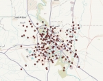
Neighborhoods, Baghdad, 2010

Baghdad City data now available through EarthWorks

June 12, 2017
by Kimberly A Durante

Faculty, staff, and students affiliated with Stanford University can now find and access GIS vector shapefile data for Baghdad, Iraq using the EarthWorks discovery platform.

Created by LeadDog Consulting, this collection contains layers representing city streets, land use, points of interest, bodies of water, airports, neighborhoods, and railroads from 2010.

Columbia Glacier retreat

Geospatial information and the 2018 Federal budget

June 2, 2017
by Julie Sweetkind-Singer

President Trump released the proposed 2018 Federal budget, A New Foundation for American Greatness, on May 23, 2017.  The budget request for the Department of Interior is $11.7 billion, 12 percent ($1.6 billion) below the Continuting Resolution baseline level.  The proposed cuts to the United States Geological Survey (USGS) are 13% or $137.8 million below the 2017 Continuing Resolution baseline level.

2017 NGAC membership

National Geospatial Advisory Committee spring meeting

April 5, 2017
by Julie Sweetkind-Singer

The National Geospatial Advisory Committee (NGAC) held its first meeting of the year in Washington, D.C. on March 21-22, 2017.  The NGAC is a Federal Advisory Committee (FACA) to the Federal Geographic Data Committee (FGDC).  The role of the NGAC is to provide advice and recommendations related to the national geospatial program and the development of the National Spatial Data Infrastructure.

A productive week at Geo4LibCamp 2017

February 7, 2017
by Darren Hardy PhD

Geo4LibCamp is a hands-on meeting to bring together those building repository and associated services for geospatial data to share best practices, solve common problems, and address technical issues. We met at Stanford University for the second Geo4LibCamp unconference from January 30 until February 3, 2017. Nearly 50 attendees from 30 institutions participated in the main three day event, and about 20 attendees for the two day post-conference working sessions. The institutions were primarily academic research libraries -- Alberta, Arizona State, California State, Chicago, Colorado School of Mines, Colorado State, Colorado at Boulder, Connecticut State Library, Cornell, Data Curation Experts, Mapzen, Michigan, Minnesota, Moss Landing Marine Labs, Nebraska at Lincoln, New York U, Northwestern, Notre Dame, Princeton, Purdue, Rice, Stanford, UC Berkeley, UC Davis, UC Riverside, UC Santa Barbara, UC Santa Cruz, UCLA, Wisconsin – Milwaukee, and Yale.

Transparent Chart of the Heavens

The Stunning Early Infographics and Maps of the 1800s

January 31, 2017
by G. Salim Mohammed

Objects from the David Rumsey Map Collection are featured in Atlas Obscura's Map Monday for January 30, 2017, features maps from John Emslie and James Reynolds.From Atlas Obscura's feature: "Have you ever wondered what the tallest active volcano is? Or wanted to compare the height of mountain peaks and the lengths of rivers around the world?

2016 NGAC

NGAC releases transition documents

January 13, 2017
by Julie Sweetkind-Singer

The National Geospatial Advisory Committee (NGAC) has released three documents of interest to the geospatial community.  Two of the documents were written to aid in the transition to a new administration in Washington, DC.  The third document is an overview of emerging technologies that will impact the geospatial landscape in the near- and mid-term future.  Taken together, these works provide a broad overview of the thinking of the NGAC members as they look forward to the next few years in the geospatial sector.

Pages

RSS